Irrigation Storage Assessment 
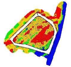
As a recognised technology for the assessment
of soil profile deep drainage characteristics, EM surveying
is ideal for targeting investigations of existing irrigation
storages or prior to development. The lowest conductivity
areas are likely to be soils with the highest drainage characteristics
within the surveyed area. The following sample map shows
a low conductivity area in the lower right of the storage
(blue area) that corresponded to sandy subsoil and extremely
high drainage. Managers are able to evaluate likely requirements
for remedial actions, movement of existing walls to isolate
problem areas or in extreme situations to abandonment of
storages at unsuitable locations.
Click on image to view enlargement
Irrigation Storage – EM31
Survey